Alongside product development, COASTDyn has completed an extensive first validation campaign using independent in situ and satellite observations to assess the performance of its new coastal datasets.
For the Coastal MDT product, validation relied on independent ADCP moorings, glider current measurements and drifter observations in the Lofoten-Vesterålen region. Comparisons focused on current velocity, speed and direction. The final MDT solution showed the most consistent improvements in the target coastal areas, particularly around the Lofoten shelf and the shelf break, demonstrating the value of combining SAR-derived currents with innovative hydrographic reconstructions.
The MIOST + SWOT KaRIn sea-level mapping product was assessed against independent SARAL/AltiKa along-track altimetry data and tide-gauge records from the GLOSS-CLIVAR network [Global Sea Level Observing System | GLOSS]. Validation analyses quantified mapping errors, effective spatial resolution and coastal performance. Results confirmed that the integration of SWOT KaRIn observations delivers a systematic reduction of mapping errors compared with conventional nadir-altimetry mapping approaches, with benefits in coastal environments.
The experimental coastal-tide developments were evaluated using 124 tide-gauge records from the TICON-4 network [TICON-4: TIdal CONstants based on GESLA-4 sea-level records] across the Wadden Sea. Validation focused on the reconstruction of major tidal constituents derived from SWOT and FFSAR observations. The results demonstrated the feasibility of combining the two observing systems, with measurable improvements for several tidal constituents in areas where reliable observations are available, while also highlighting the challenges posed by coastal sandbanks and data quality nearshore.
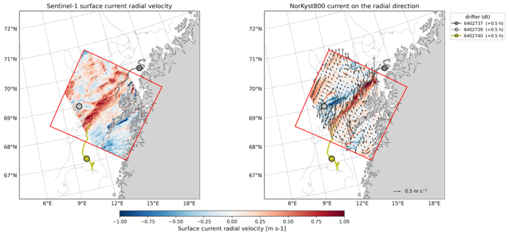
For the SAR-derived surface current product, Sentinel-1 radial velocity measurements were cross-compared with the high-resolution NorKyst800 coastal ocean model [Ocean Models | OCEAN.MET.NO] and available surface drifter observations. Dedicated analyses were performed to characterize noise, coastal artefacts and the temporal variability of current signals. The validation demonstrated the capability of SAR observations to capture major circulation features and their variability in the Lofoten-Vesterålen region, while also identifying key areas for further refinement in future developments.
The FFSAR dataset was subjected to dedicated quality control and processing, including noise reduction, nominal-track mapping and consistency checks with coastal sea-level observations. These developments successfully delivered a multi-year high-resolution altimetry dataset over key coastal regions, providing the observational foundation required for the tidal experiments and future coastal-altimetry applications.
The development of these algorithms, the creation of these datasets, and the associated validation activities achieved during the first year of the project, provide a robust foundation for the project’s next phase which will focus on scientific use cases in the Lofoten-Vesteralen region, the Wadden Sea, and the Biobio/Arauco Gulf in Chile.